
 By
By A 16th-century world map is drawing new attention to one of archaeology’s longest-running mysteries: the possible location of Noah’s Ark.
Independent researcher Jimmy Corsetti recently highlighted a detail on the Planisphere, a massive 1587 map created by Italian cartographer Urbano Monte. The map, made up of 60 hand-drawn sheets that form a circular image roughly 10 feet wide, appears to show the Ark in a location that Corsetti says corresponds with the Durupinar formation in eastern Turkey.
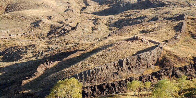
The Durupinar site, a ship-shaped mound in the Ararat mountains, has long been cited by some researchers and biblical scholars as a possible resting place of the Ark. The location has drawn interest because Genesis 8:4 says the Ark came to rest on the “mountains of Ararat” after the Great Flood, according to The New York Post.
The biblical dimensions of the Ark — 300 cubits long, 50 cubits wide, and 30 cubits high — translate to roughly 515 feet by 86 feet by 52 feet. Supporters of the Durupinar theory say those measurements closely resemble the dimensions of the Turkish formation.
439yr old map created by Urbano Monte in circa 1587, depicts NOAH’S ARK on the Ararat Mountain’s of modern Turkey
Old Testament: “The Ark came to a rest on the mountains of Ararat…” -Genesis 8:4
The same location of ‘Durupinar’ site, which is virtually the same exact length 🤯… pic.twitter.com/mx1pnEMhRG
— Jimmy Corsetti (@BrightInsight6) May 25, 2026
The Planisphere, now held at Stanford University’s David Rumsey Map Center, combines geographic knowledge from the Age of Exploration with illustrations of ships, animals, distant lands, and mythical creatures. Corsetti argues that its depiction of the Ark adds historical weight to claims that the Ararat region was long associated with the biblical story.
The site has been studied for decades, including through the Noah’s Ark Scans project, which has used ground-penetrating radar and other tools to examine what lies beneath the surface.
Researchers involved with the project say radar scans have detected corridors running through the center and edges of the formation, converging near what they describe as a central atrium. They argue that the layout is consistent with the Bible’s description of a three-deck vessel built to carry Noah’s family and pairs of animals.
“God told Noah to bring the animals in. And so these animals would have stayed there, plus Noah and his family,” said Andrew Jones, a researcher with Noah’s Ark Scans. “What’s interesting is that these voids are lining up below the ground – and they’re not just random.”
The team has also used infrared thermography, which it says detected what appears to be a buried ship-shaped hull. While researchers acknowledge that intact wood is unlikely to survive at such an extreme age, they say soil samples collected from the site may point to decayed organic material.
“In 2024, we took 88 random soil samples inside and outside of that ship shape,” Jones explained. “And what they showed was that the soil inside the ship shape had three times more organic matter than right outside, and 38 per cent more potassium.”
Soil scientist William Crabtree, another member of the Noah’s Ark Scans team, said those chemical differences are significant.
“If you know soil science — as I’m a soil scientist — you’ll understand that potassium levels, organic matter, and pH can all be influenced by decaying organic material,” Crabtree said. “If this was a wooden boat and the wood had rotted over time, we would expect to see elevated levels of potassium, changes in pH, and higher organic content — and that’s exactly what we’re finding.”
Other findings, including coral and seashell fossils discovered at roughly 6,500 feet in elevation, have fueled speculation among supporters that the region may preserve evidence of a massive ancient flood. Skeptics, however, argue that such marine fossils can be explained by geological forces, including tectonic uplift, rather than a single global deluge.
For now, the Durupinar formation remains a source of debate. To supporters, it may be the preserved outline of the biblical Ark. To critics, it is more likely a natural geological formation whose shape has invited centuries of speculation.
Corsetti’s reading of Monte’s map does not settle that question. But it adds another layer to the mystery, suggesting that long before modern radar scans and soil testing, early mapmakers were already linking the mountains of Ararat to one of the Bible’s most famous stories.
[Read More: Homeward Bound: Mustang Comes Home After Wild Trip]