

Archaeologist Richard Hansen of the Idaho State University and his colleagues recently made an incredible find as they flew over Guatemala with the latest radar technology called LiDAR, an acronym for for laser imaging, detection, and ranging.
The images showed something unexpected: “An aerial survey has revealed a previously unknown wealth of Maya cities, towns and villages in northern Guatemala: more than 400 settlements, many connected by causeways that would have required vast amounts of labour and material to build,” Nature wrote.
To make sense of the sheer volume of finds, the authors of the study grouped them into different tiers, based on size, types of buildings and monuments, hydrological and agricultural features and plazas/ballcourts. These are in turn linked by an extensive causeway system. pic.twitter.com/XqXBulL9ia
— Stone Age Herbalist (@Paracelsus1092) December 20, 2022
Since only a few sites were previously known from excavations, these results challenge the older idea that the Mayan lowlands were sparsely populated. The consistent styles of architecture prove there was a unified and complex political culture, capable of organising labour pic.twitter.com/LbokAMyahV
— Stone Age Herbalist (@Paracelsus1092) December 20, 2022
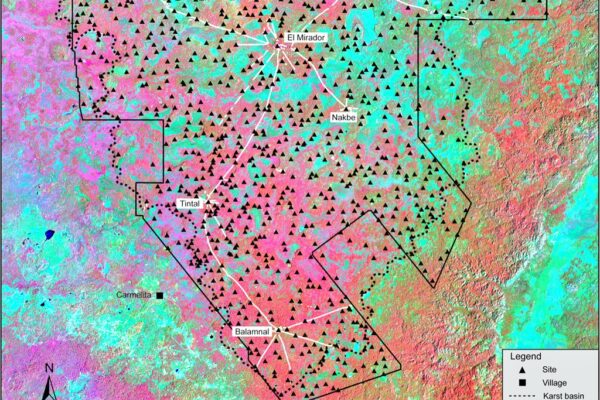
The crew of researchers “detected traces of a huge, 2,000-year-old pre-classical Maya civilization located in the Mirador–Calakmul Karst Basin of northern Guatemala. The experts revealed the presence of some 1,000 ancient Maya settlements using LiDAR — a system similar to radar, but based on laser light rather than radio waves. An advantage of LiDAR is the laser used can penetrate the canopies of vegetation in dense tropical rainforests, revealing what is hidden on the ground beneath them, according to Express.
They said: “The LiDAR survey revealed an extraordinary density and distribution of Maya sites concentrated in the Mirador–Calakmul Karst Basin, many of them linked directly or indirectly by a vast causeway network.
‘Using hillshade models derived from a LiDAR digital elevation model, at present 775 ancient Maya settlements — defined as an architectural cluster — have been identified within the southern lowland Mirador–Calakmul Karst Basin, of which 581 are unnamed.
The team continued: “An additional 189 ancient Maya settlements of varying sizes were identified within the geomorphological borders of the southern Mirador–Calakmul Karst Basin… for a total of 964 settlements, of which 645 are unnamed as yet.”
“An additional 52 known sites are located on the Campeche side, but without the benefit of contiguous LiDAR, with the exception of dispersed areas in Campeche, Mexico.”
Hansen’s discovery has been called set of “super highways” that connected towns to each other. The linkages show a large civilization that we are still trying to learn about and understand.
The Yucatan Times reported, “El Mirador is a late Maya preclassic city, located in Guatemala, in the heart of the Petén jungle, and it was recently revealed that the first network of super highways in the world was made there by this ancient civilization.
This was concluded in the framework of the “Cuenca Mirador” archaeological project, in which more than 700 square kilometers have been analyzed by experts. In addition, Richard Hansen, director of this program explained that this a one-of-a-kind study ever to be conducted in Mesoamerica.
In total, it is estimated that El Mirador, also known as the the “Kan” Kingdom, covers an area of 2,158 square kilometers within the Maya Biosphere Reserve and is also one of the most important environmental lungs in all the American Continent.
According to Hansen, this was the first state in all of the Americas, and in its time could have been the largest in the world, both in size and population, as it is estimated that at least 1 million people lived there before it collapsed, around the year 150 BC.”
Before naming the uncovered places, Hansen and his team of researchers must first understand how the system worked. That means they’ll first have to establish towns from cities and villages.
Artnet described the problem. “The definition of these terms is a thorny issue,” the study read. Some settlements that would’ve been perceived as independent without LiDAR now look more like they’re interconnected. At present, the team has condensed all 964 settlements into 417 different entities according to six tiers based on elements like their surface and architecture.
What the experts know for sure, however, are the characteristics of individual features they’ve found, including 30 ball courts, 195 cement reservoirs (some converted from sunken ceremonial centers to account for the area’s lack of lakes and rivers), and the society’s “crowning achievement,” 110 combined miles of elevated causeways crafted from lime and clay mixtures.
The team even explored remains of the 230-foot tall pyramid of Danta in the Maya city of El Mirador, once the center of the metropolis and one of the largest ancient structures. It would have taken 158 workers five years just to quarry the 205,508 limestone blocks comprising the pyramid, which likely required six to 10 million days of labor to build.”
The research team plans to continue to study the area to understand how they were built.
[Read More: Cat Comes Home After Six Years, Finds Owner Waiting]


Whole Central America North is a Mayan super city day 1
Open up Area for Tourism alone $$$