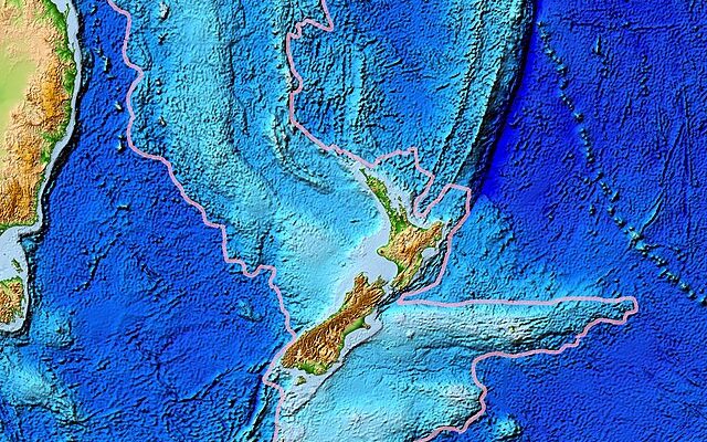
After decades of work, a team of researchers has mapped the world’s eighth continent, the sunken continent of Zealandia, a landmass that covers an area of about 1.9 million square miles in the Pacific Ocean. It’s about half the size of Australia.
The concept of Zealandia has long been considered, but it gained recognition recently, as geologists conducted extensive research on the region’s geology, tectonic activity, and continental crust.
The new maps will allow humanity to unlock its long-held mysteries, including how it became submerged under the ocean.
The continent has been was hidden, writes Insider, “lost for millennia, because 95 percent of it is underwater. That makes it extremely difficult to map since most of its volcanoes, valleys, rifts, and mountains lie at the bottom of the ocean near New Zealand.
But that didn’t deter scientist Nick Mortimer, who led the team that’s been studying Zealandia for over 20 years.
In a new study, the team finished mapping the final piece of the continent, the northeast corner.
Combined with their data from years of research, they’ve mapped the continent’s surface features like plateaus and ridges. As well as the boundary where the continent and ocean usually meet — a feature that’s largely unknown for other continents, because it’s not typically studied, Mortimer said.
“As far as we’re aware, this is a world first,” Mortimer, a geologist with GNS Science who led the study, told the outlet.
Zealandia – the 8th continent.
Scientists Discover 8th 'Continent' That Had Been Missing For 375 Years
The new continent is 94 per cent underwater, with just a handful of islands, similar to New Zealand.#zealandia#WorldTourismDay pic.twitter.com/0MXHU4c4fM
— alphabetagama (@alphabetagama20) September 27, 2023
The “missing” continent has been a puzzle for scientists for decades.
“Zealandia is thought to have formed around 83 million years ago, during the Late Cretaceous. However, its journey began up to 100 million years before that, when the supercontinent of Gondwana – which congealed much of today’s land into one giant lump – started to break up. As it disintegrated, the world’s smallest, thinnest and youngest continent struck out on its own, while the regions of Gondwana that had once laid directly to its northwest and southwest became Australia and Antarctica, respectively,” according to BBC.
It’s thought that all or part of Zealandia may have existed as an island for a while. But then around 25 million years ago, it was disappeared beneath the ocean.
The first real clues that New Zealand might represent just a tiny, visible portion of a vast incognito landmass came in 2002, when scientists used bathymetry – the study of the depth of bodies of water – to analyse the region. The ocean above what we now call Zealandia is considerably shallower than that surrounding it, suggesting that the area was not underlain by an oceanic tectonic plate – like most of the world’s oceans – but a continental one.
The clincher came in 2017, when scientists put several lines of evidence together, including data about the kinds of rocks it contains and its relative thickness – oceanic plates tend to be thinner – to propose that this is indeed a new continent. This is not a mere continental fragment or microcontinent, as had previously been proposed, but the real deal, 95% of which is submerged underwater.”
Popular Mechanics explained how it sunk: “the internal deformation of both Zealandia and West Antarctica show that stretching led to the subduction-style cracking of the plates that welcomed ocean water to form the Tasman Sea. Then, a few million years later, further Antarctica break-away continued to stretch the crust of Zealandia until it thinned enough to break apart and seal the largely underwater fate of Zealandia. This goes against the prevailing theory of a strike-slip breakup.”
Looks like it might be time to update the geography books.
[Read More: Police Couldn’t Believe What She Was Using As A Pillow]





Have AI rewrite the textbooks